NDVI Crop Stress Detection Across Agricultural Regions
Detect crop stress and irrigation deficits before yield loss occurs. Klarety agents compute normalized difference vegetation index from Sentinel-2 10-meter bands, threshold anomaly zones against seasonal baselines, and generate field-level risk maps. Farmers and agronomists receive stress alerts every 5 days — no GIS skills, no satellite expertise.
Monitor crop healthCrop stress detection for agronomists and traders
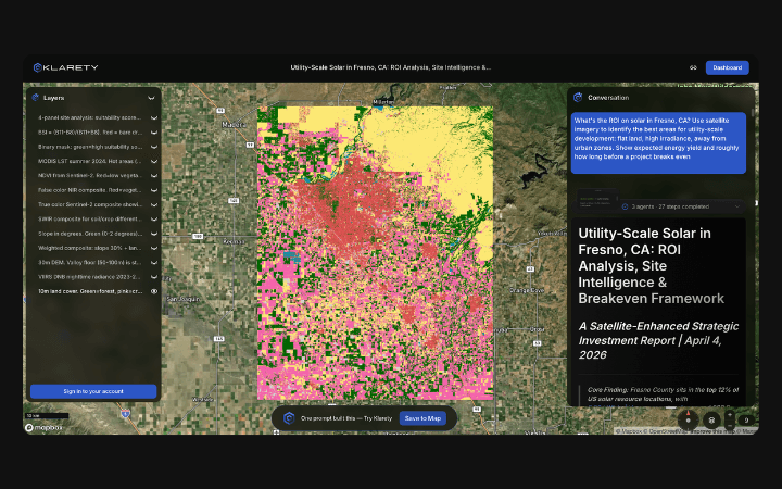
Field-level stress maps from one satellite query
Klarety agents compute NDVI anomaly zones from Sentinel-2 10m bands and return field-level risk maps every 5 days.
Seasonal baseline anomaly thresholding
Agents compute NDVI deviations against seasonal baselines and classify stress severity by zone with confidence scores.
Stress layers for precision agriculture GIS
Export stress zone polygons with severity classifications for farm management systems and GEE workflow integration.
Sentinel-2 NDVI anomaly detection for crop stress
Klarety agents compute a 5-year seasonal NDVI baseline from Sentinel-2 for each field polygon, then flag current NDVI values more than 1.5 standard deviations below the baseline as stress zones. Severity is classified as mild (1.5-2 SD), moderate (2-3 SD), or severe (>3 SD). Output is a field-level GeoJSON with stress severity, confidence, and affected area per field.
Klarety AIMonitor crop stress in your region